Part 3 of "Design Behind the Ancient Mysteries" (from 2005). I thought this would be a 4-part presentation of the original paper, but I see that what would have been part 4 was in fact included in the 2009 post, Challenge to Science III, as an "UPDATE":
The “gods” adopted the idea of projecting the celestial sphere onto the terrestrial globe in order to record their design deeds. They provided for a whole series of precise, easily-identifiable mappings of “heaven on earth”, by shaping landmasses on Earth to match constellation forms (Figure 10, next page). For example, the main form of the constellation Cepheus can be precisely mapped onto the African Horn, the forepart of the constellation Centaurus closely resembles the form of the eastern coast of North America, Crater can be precisely fitted to Hudson Bay, and so on.
Such wholesale, precise re-formations of continental landmasses by the “gods” would explain the creation accounts, in Genesis and in other religious traditions, which stressed that God “separated the land from the waters.” These re-formations also left the landmasses with an abundance of creature-like shapes, almost all upright on the globe and hence clearly the work of design. These creature images can be identified with the best known of mythological characters, worldwide (as treated in some detail in "The End of the Mystery").
Only in the last century has science shown that the continents have indeed been broken up, moved over the surface of the Earth, and re-formed. The idea of “continental drift” was resisted for decades, because geophysicists saw no natural force capable of it. But the design of the "gods", and the ancient testimonies that derived from it, are quite clear (again, as detailed in "The End of the Mystery"): The designers broke apart, moved, and re-formed whole continents into their present locations and shapes, in order to enable various constellation forms to be matched to various landforms, in a series of mappings of "heaven onto earth" that, together with the myths and other ancient traditions of mankind, tell the story the "gods" wanted to leave behind for man to find, when he had grown enough in understanding to see it. These mappings were undoubtedly the objective origin of the ancient religious tradition, and prime hermetic dictum, of "as above, so below", or "on earth as it is in heaven." (This should not be taken as the only meaning of that worldwide tradition; it was affirmed as a primary spiritual truth. The author’s research has been to establish the objective, physical origin of the world’s strikingly similar mythologies and traditions, not to deny the spiritual.)
A particularly clear demonstration of the fact of the design, and its precision, is shown in a generic mapping of the celestial sphere, as in Figure 2, onto the Earth, which may be termed a precessional mapping, with the celestial north pole mapped onto the terrestrial north pole. Figure 11 shows such a mapping, whose defining feature is the location of the vernal, or spring, equinox point on the Earth, which was established at the island of Sulawesi.
Sulawesi (formerly Celebes) is shaped like the mathematical symbol and Greek letter "pi", and the author has verified the ancient use of that name, "pi", for the vernal equinox point on the Earth. Figure 12, next page, shows a close-up of this point, showing how the adjacent coast was curved around it, with a diameter the same as that of the Sun in the sky (0.53 degrees), to represent the point where the Sun rises above the (celestial) equator, on the first day of spring.
This point on the equator, at the very tip of the Manimbaya peninsula, was the literal "spring of Urd (Earth)" of Norse myth, an identification which enables one to precisely locate all the major points of the Norse mythography (Figure 13).
This part of the Earth was named the "Orient" to refer to the symbolic "rising" of the Sun here as on the vernal equinox; it was called the "East" for the same reason, because the Sun also "rises" each day (above the horizon), in the east. Also, Figure 12 refers to a "Great Mapping", according to which the Earth was designed; in this mapping, Japan lay along the rising path of the Sun--and so it was called the "land of the rising sun" (although it is not the only land on that path).
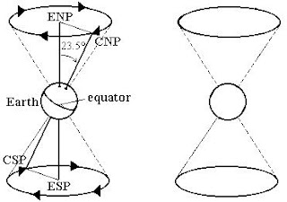
Four of the mappings identified by the author, in particular, unequivocally and precisely show where the ENP formerly was on the celestial sphere, by identifying the former precession circle around it (Figure 14)--proving that the orbit of the Earth, and the entire solar system (which is predominantly aligned with the Earth orbit), was deliberately changed from that previous orientation.
Readers are referred to The End of the Mystery for a fuller treatment of this and many other revelations provided by the great design of the "gods".


